Thursday, October 24, 2013

Beaver Creek Loop - The hike to change all hikes

We decided to do this hike based on the description here:  http://www.everytrail.com/guide/beaver-creek-loop  It is everything described here and more.  There are also good directions to get to the trailhead along with a play by play description of the hike.  Good information.  To bad we didn't study it a little harder!  This hike was a little longer than we have been doing, 7.3 miles, but we felt we could do it easily seeing as we had done the comparable length Waldo Canyon many times.  The last time we hike Waldo Canyon we finished in about 2-1/2 hours and we expected the same here.  I fully expected to join my sewing buddies back in Colorado Springs at 1:00pm seeing as we got an early start.  Ha ha!

On our drive to the trailhead over the dirt road we were delighted to see several wild turkeys.


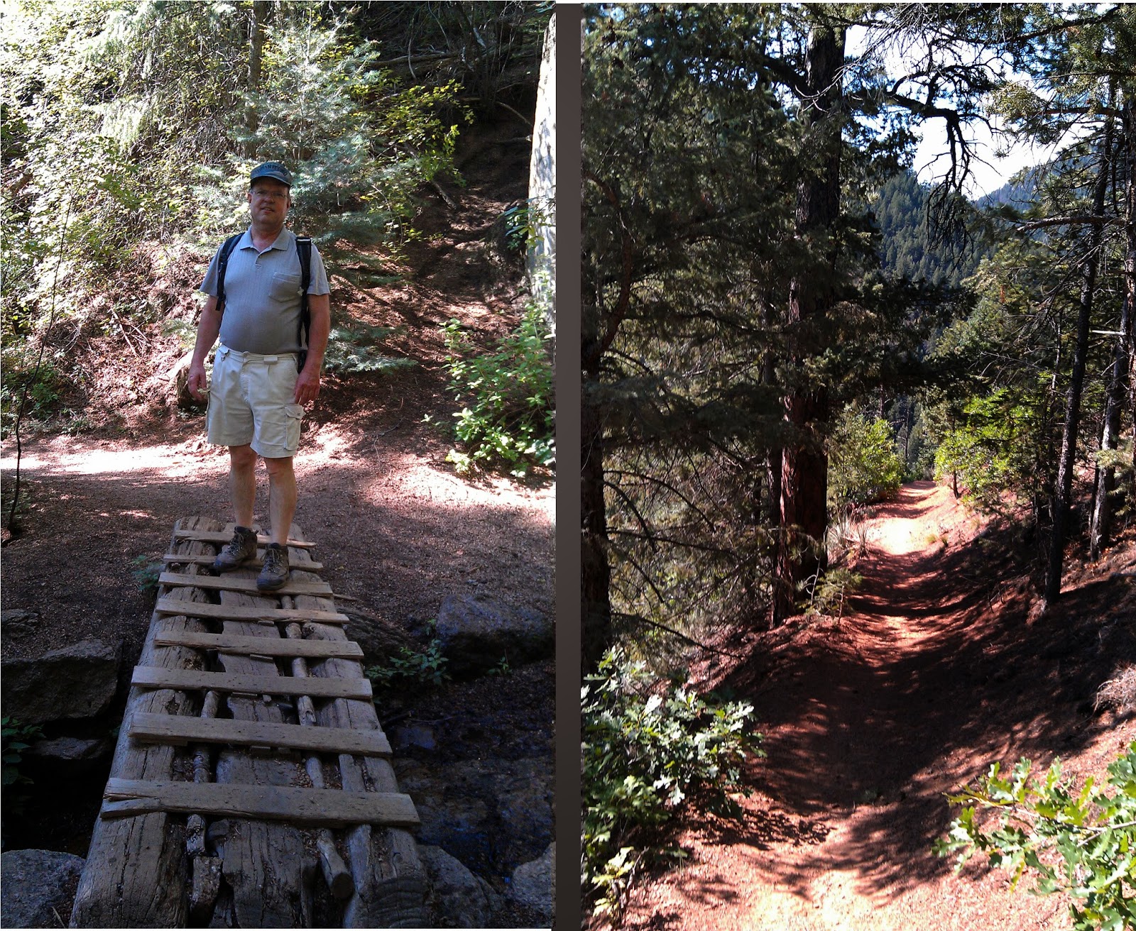
Here is where the trail starts:


We packed as we always do -- backpack with snacks and a large water bottle for each of us.  As I'm recalling this from memory I wouldn't use my description as a guide!  The first hour or so was a very enjoyable hike.  The trail was wet in parts.  We laughingly joked about this being our first creek crossing.


Some ups, some downs, some parts of the trail were rocky.  The rocks made progress slower going for us.


We also walked through a valley that had more undergrowth than we are used to in Colorado.  It was also very moist and close enough in one area that we could feel the moisture of the weeds brushing against our legs.  In this area we were bothered by mosquitos - another rare occurrence in Colorado.  Luckily I just happened to have some spray so I got it out -- first and only use so far!  While we were put-zing around, I looked around and there was a lovely deer looking down at us.  It ran away before I could snap the magestic frontal photo.

We had only a small while left of this blissful hiking adventure before it turned ugly.  Here are some images so you can enjoy it too.  In some places there were lovely wildflowers.  This is very different terrain than the rocky cactus scenery we hiked from to get here, but no less or more beautiful.


At a sign we turned left onto Powerline Trail.  This was the beginning of an endless uphill climb.  Luckily we are starting to get used to these, especially after hiking section 16.  Although long, we tolerated it quite well.  Towards the top we were treated for our efforts with exquisite vistas only God is capable of painting. I got a text from my friend asking me if I was going to make it to sewing.  I text-ed her a photo and told her I would when I got off the mountain I was on.


After hiking at the top for a while we descended for a bit and then climbed back up to another crest.  Then we began a long continuous downhill trek.  It was steeper than the climb up which traversed back and forth across the hill making it easier to climb, but not too steep to make the climb down very difficult.  There were some spots where the trail became questionable - like where was it and is this really where we are supposed to descend?  There were some beautiful views of rocky mountains that for some reason I didn't take pictures of.  I think I was reveling in not climbing up -- a lovely feeling that is only slightly dampened by the new muscles you are using to go down.  (-;  My husband didn't have the best shoes at this point in our hiking adventures and later his toenail turned purple from constantly hitting the front of his shoes.  Next stop - new hiking boots.  (-;

Some parts of the trail are well marked.

 Unfortunately, others are more simply marked.
I seem to remember seeing a cairn of rocks like this with a less defined trail branching off of it.  We have seen this many times while hiking and have always taken the road more traveled so I thought nothing of it.  Plus we were still on the high of going downhill.  (-;  Until we got to here.

This is the end of the trail and where two creeks merge.  Yes, the end of the trail.  So this is where we pulled out our printed instructions and realized we probably should have turned off a while back.  There was NO going back from my point of view as I clearly remembered the joy of downhill that lasted seemingly forever (without any switchbacks) and suffered no delusions about what hiking back up it would be like. There was no option to follow the stream on our side of the stream because the stream ran into a rock face.  So we took off our shoes and crossed stream one first and then stream two.  We thought it was better to have some rocks for balance or we could have just crossed the single merged stream.  I had to gather courage for this.  I am diabetic and was not fond of the idea of crossing in my bare feet.  The rocks under water are slippery.  We made it to the other side and there was a wide open spot between trees where it looked like people had camped.  We tried to find a trail but there was none and eventually we ran into thick brush and couldn't proceed.  Our only option was to cross back over the stream again.  We were able to cheat a little (using a downed tree) and didn't have to take off our shoes again, plus we found a stick to cross with.

We still couldn't find a trail so we just followed the creek for a while which wasn't too difficult to do.  I had downloaded the track to my phone, but it was starting to run out of charge.  Didn't make us happy.  For one, we weren't really sure where we were and if we were proceeding correctly.  We kept running into rock faces and had to cross the creek again.  So, we took off our shoes, crossed the creek, put back on our shoes and hiked until we could hike no more.  Then we'd cross the creek again.  At one point we had just crossed the creek, put on our shoes, and 20 feet later had to cross again.  It doesn't sound like it would be difficult to take off your shoes and put them back on, but it was tiring to do it again and again, especially after the never ending uphill climb we had made.  Plus, being sort of lost, the stress was getting to us.  We were reasonably sure we would make it back to our car, but not entirely sure.  The desire to get to a point where we were sure made us want to press on and not take proper breaks.  I read that you also go faster and tire yourself out when you are stressed.  Not to mention that some crossings have their own crossing guard like the huge wolf spider below.  We tried to find places to cross the stream where trees had fallen (or been dragged across) or where there were large boulders to hang on to.


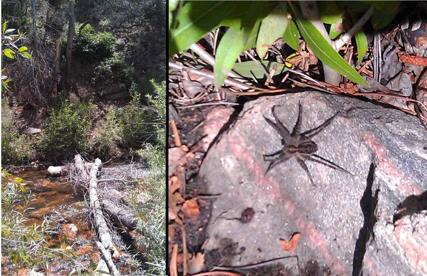
At one point I became so frustrated upon realizing we had to cross the stream one more time I sheepishly admit that I started crying.  My husband, afraid I was going to give up, told me harshly to "Stop it right now".  I responded by ... crying harder.  Hugs all around.  (-;  It was in that crossing that I fell into the stream.  Instead of quickly jumping out, I sunk into the coolness of it.  It was refreshing in the heat.  It wasn't until later I realized that I actually hurt myself.  My elbow hit a rock and later I looked down to see it was swollen to the size of a golf ball. I could move my arm alright, but it hurt to touch it. If I wasn't in such dire straights I would have enjoyed the scenery more. Gorgeous!

A couple of times we thought we'd found a trail just to follow it to a dead end. More frustration. Finally we did find a trail (yay!) and started to follow it. More uphill climbing and I am barely able to put one foot in front of the other. At one point we came close to the creek again and I poured a bottle of water over my head and it gave me a second wind. I think I was hotter than I realized and the heat was affecting my ability to proceed.  I had no hat - not smart. This trail is further south where the heat is usually a good 10 degrees hotter than we are used to. We finally hiked up to the trail where we remembered seeing a sign post early on that we could have hiked down to the creek near to the beginning of the trail. It was such a relief to be in familiar territory. Good thing as we were nearly out of water and hadn't been able to drink as much as we wanted. It was a longer hike to the car from here than we remembered. We ran into two women hiking in - the only people we saw all day. It was about 3pm in the afternoon by the time we got to the car. Two things I remember -- one was that I was being eaten alive by mosquitos waiting for my husband to change shoes.  The other was how grateful I was that he thought to pack a small cooler with fresh drinks in the trunk of our car. I was so thirsty and it just saved me.

This hike shook my faith in myself. I made the decision that I would make sure my bag was packed for any contingency. Major lessons learned:  Find out all you can about the trail your hiking before you go -- read any instructions carefully to know what you might face. Have a topographical trail map and check landmarks around you before you start your hike. We didn't know how close the creek was to our car and so weren't sure if the creek would lead us to the trail head. We thought it would eventually lead us to somewhere civilized. You can also check your landmarks for bearing if you feel you have gone astray from your trail.  Have a GPS so you know if you are returning to your starting point. However, a GPS can show you that you have to hike from point A to point B to return to your starting point -- what it doesn't tell you is that there is a rock face you can't hike through -- great reason to keep your topo maps. Have good hiking shoes. Carry extra water for hikes new to you. Wear a hat to protect you from the heat.  Know that bug spray is sometimes necessary in Colorado.  Water socks and hiking sticks would have been nice to have while crossing the creek. Be prepared for an overnight stay in case someone gets sick or hurt. These days we are much better prepared to hike in the mountains.

Sunday, October 20, 2013

Elder-Fehn Trail

Total distance: 5.4 miles
Elevation – Min: 9442 ft, Max 9956 ft.
Total Ascent: 1930 ft.

We wanted to hike a longer hike today and intended to hike the Elder-Fehn Trail to the Vayhinger Trail and then follow the Ring the Peak Trail to Limber Pines Trail, but when we got there we discovered that the North Slope Recreation Area (NSRA) was closed from 1 Oct to 1 May.  We were still able to hike the Elder-Fehn Trail. 


This trail can be reached by traveling west on hwy 24 from Colorado Springs just past Woodland Park and then taking a left onto Edlowe road.  At the end of this road there is a parking lot with a restroom and this is the trail head.  On our drive to the trail head we saw a bunch of turkeys with an excellent backdrop of Pike's Peak.  I didn't bring my camera today so was limited to using my phone for pictures, but I got this excellent shot:


Initially we climbed about a tenth of a mile or so where Elder-Fehn Trail branches right while to the left is a locational sign and a gate which leads to Limber Pines Trail in the NSRA.  We took the right (the left was  closed) and were surprised to see that there was snow on the trail since we had hiked Dome Rock the week prior and not seen snow.


There are a lot of ups and downs to this trail with occasional views of Pike's Peak which was snow covered today.


 There were only a few aspens left with any color to them.  Much of the sky is cloud covered, but there is some blue sky showing.  When we checked the weather this morning Woodland Park was supposed to go cloud covered by 11:00 and have a 60% chance of snowfall by 4:00 although not much was expected.  When we started at 8:45 it was about 36 degrees.  I had 4 layers on top and 2 on the bottom.  Within 30 minutes I had shed two layers on top, ditched my gloves and snow hat.  I still wore a visor.  Most of the trail goes through a wooded area.  At one point the trees thin out and it becomes fairly rocky.  We stopped here for a snack.


Just past this point we noticed some turkey tracks, so apparently the turkeys do some mountain climbing of their own.

There are all sorts of signs telling you to stay on trail.  The trail is also marked on trees with reflective disks at eye level. 


Eventually we passed the sign for Vayhinger trail to the left.  It wasn't blocked off, but you could have only hiked down it for about a mile before it would have entered into the NSRA and been closed.  We aren't sure why the NSRA closes their trails from Oct to May.  We circled around the loop and headed back the way we came. This was a fun hike and we'll do it again; maybe in the summer when all the trails are open for hiking.


Saturday, August 10, 2013

Raspberry Mountain Trail in Divide, CO

Here are good instructions to get to this trail:
http://www.everytrail.com/guide/raspberry-mountain/map#poi-3
This is a trail that climbs to the peak of Raspberry Mountain that is about 6 miles long.  The climb is gradual until the very end when there is a steeper climb to the top where there are phenomenal views. 

We started pretty early in the morning and the air was crisp and cold at the start.  Here is a picture of the trail head from the road:
You can see the sun is just beginning to warm up the air and steam is rising from the meadow at the trail head.
There are still mountain flowers to be seen.
Here we've climbed into a young aspen grove.
Here you can see that the trail is wide and sometimes eroded.
 More shots of the trail.

 Towards the top the trail dies out a bit and the whole forest looks like a trail.  In the photo on the right you can see our destination -- it is the rocky peak in the background.  There is some steeper climbing up ahead that will be well worth our troube.
 The squirrels often scold us as we walk by.  Willy likes to tease me that they are demanding a toll.  Sometimes it seems they are throwing things at us. (-; This one posed for a picture.
 Here is a tree that was split right in half.
All along the trail are mushrooms of many types.  I really wish I knew which are edible and which are not even though some of them look extremely distasteful!  I'm guessing we found every possible poisonous mushroom you can find!
Towards the top it gets rocky...
 and there are huge boulders to our right.  Here Willy is pointing out there is snow.

 At the top there are magnificent views.  This is Pike's Peak in the background.

 The Catamount reservoir from the summit.
 Keep climbing until you reach the very top.  There is a nest like cluster of rocks at the top above the tree lines and you can take in gorgeous views 360 degrees around.


The hike down is back the way you came and much quicker than the hike up.  (-;  We were serenaded by these "Cracking Forest grasshoppers" who are amazingly noisy.  It blends in nicely with the trail.


Saturday, July 27, 2013

Section 16, Palmer Trail

We accessed the Section 16 trailhead by heading west on hwy 24, left on 21st, and then right on Gold Camp Road.  There were a group of trail maintenance volunteers working so the parking area was full and we had to park a bit further down the road.  Thanks to trail maintenance volunteers!!! 

This was a never ending climb up the side of the mountain.  We had to stop and catch a breather several times.  My husband is on a heart medication that doesn't allow his heart to speed up and he was having quite a bit of difficulty with that.  The trail is a very pretty hike through the forested mountain though.  Some parts of the trail are quite rocky. It was on this trail that we realized that a mountain trail rated moderate by some guy on the internet could be difficult.  Not only was the "internet guy's" rating subject to his personal traits (24-year-old seasoned hiker vs 50 plus in so-so shape), but that lengthy mountain hikes require a certain amount of physical conditioning even for an easy hike.  Moderate hikes are moderate because there are other mountain hikes can be exceedingly difficult.


At the top were incredible views.


The walk down the mountain was exhilarating because we had earned it!  Read that our endorphins definitely kicked in!! 


Felt good at the finish.  We are starting to realize that most of the trails here start with a climb up a mountain and end with great satisfaction.  (-;  At the bottom the trail split -- we went right where it joined a dirt road that ran along side a small bubbling creek bed.  There were some nice flowers and butterflies along side the road. 


The dirt road brought us back to Gold Camp Road where we hiked up the hill to our car.  We enjoyed the hike and are becoming addicted to the joy of hiking.  We will return when our butts are in better shape and they surely will be if we keep this up.


Saturday, July 20, 2013

Palmer Lake - near the Ice Caves

This trail is located off of I-25.  Take exit 161 and take Hwy 105 to Palmer Lake.  I don't remember exactly what road we turned left on, but from google it looks like Glenway Street.  I think we got these directions online somewhere, but I can find it now.  You will see a gorgeous victorian estate on the right with a yellow victorian house and several out buildings.  I loved going this way just to see this!  It was for sale when I was there -- but at $2.7 million with furnishings included it was out of my price range.  lol!  I keep it in mind for when I win the lottery.  Later I found out this is Estemere Estate and there is a website with the history and photos online (http://www.estemere.net/).  It's even got a small chapel and potential for an art studio.  But I digress. I understand there is a trailhead from other descriptions on how to get there.  This may be the better way to go.  We did have to park near the Victorian estate and walk up the road to the gate where the trail goes up.  We could see that others were hiking up from another location -- probably the trailhead. (-;


 The first half mile is a grueling hike up hill until you reach the first reservoir.  There is a second reservoir further up that we hiked to.  Apparently to get to the ice caves you take the less developed trail to the right.  We went left and explored some trails over that way and so never got to the ice caves.  This is a really pretty hike.  Close to the reservoir there is an entirely different ecosystem than elsewhere we've been in our mountain hikes.  It is really wonderful.  There are lots of blooming flowers this time of year and butterflies.  There were several people fishing and walking about.