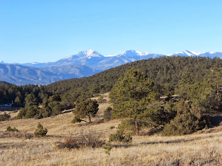
This weekend we decided to participate in a guided hike of a volcano crater near Salida, CO. We took Hwy 24 to Hwy 285 on the way there and Hwy 50 to 115 on the return drive home. Here we stopped at Wilkerson Pass to enjoy it's beauty. One year when Willy, Meg and I drove through the valley on our way to skiing the road was lined with 5 feet of snow on either side. It was astonishing. We never saw it again or since so perhaps it was before the drought or was an anomaly. It is too early to have snow like that now.
We
arrived the night before to find the meeting point and because we had
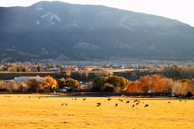
an 8:00am meeting time. Just outside of town we saw this meadow and a
very large gathering of deer -- more than I've ever seen in one place
together. It turns out that these deer are smart enough to come inside
the city limits where hunting is prohibited to avoid getting shot!
We stayed at the Comfort Inn which turned out to be very comfortable.
In the morning volunteer
naturalist Bob Hickey led us and 17 others up the trail to the volcano
crater. It took longer hiking out than the return because Bob stopped
several times to let us in on some very interesting geologic
information. On the way back we separated from the group and hiked on
our own.
GPS Readings:
Distance:
8.1 miles
Elevation
Gain: 395 ft (8865 to 9260)
Total
Ascent: 1818 ft
Elapsed
time
2:57
outbound
1:31
return
-------------------------------------------------------------------------------
The Directions and Hike Overview are paraphrased versions of the email we got explaining the hike.
Directions
to Trail head:
Turn east off CO Hwy 291 onto
County Road #175. Proceed
east on County Road #175 for 6.6 miles. At the Y bear right continuing on County Road #175.County Road #175 leads up through Ute Creek
Canyon to the intersection of Forest Service Road # 181 on your
right. We met Bob and the other hikers in the large parking lot on the right. From there we drove up the smaller dirt road branching off the parking lot another
0.7 mile south on US Forest Service Road #181 to begin the
hike. We parked our cars when we reached the large meadow and began our hike down the dirt road.
Hike
Overview :
We
began the hike in an open meadow with nice views of the surrounding area and
soon entered the forest, walking along a west facing hillside with periodic open
views. For this entire first segment of the hike we were in the lower (Kerber
Formation) to middle (Minturn and Sharpsdale Formations) Pennsylvanian
sedimentary rocks. As we dropped into upper Cottonwood Gulch we entered the volcanic
rock zone of the Salida Volcano Field. We encountered a beautiful pond as we
cross to the south side of the Gulch and began our climb out beside Rick
Mountain (a large volcanic deposit). The dirt road then followed the west slopes
of Big Baldy Mountain (the main volcano in this area) to a saddle connecting Big
Baldy with “The Crater” (a side vent volcano of Big Baldy) through mostly
varying kinds of volcanic deposits (some Pennsylvanian deposits and a
Granodiorite lacolith do protrude the volcanic covering in spots). We followed the
trail across the saddle and up the southeast side of the cone to the top of “The
Crater” where we had lunch before returning via the same route.
------------------------------------------------------------------------------------------------------------------------
We weren't sure whether to expect snow or not, but we saw very little. It was a perfect day weather wise -- the temperature reached into the 60s. Initially we were cold waiting to get started on the hike. It was a good reminder that the only reason we are warm enough hiking in the winter is because we are moving. For this reason I pack extra clothes in case something happens where we can't move. We did hear some hunters firing away on the mountain, but there were no bullets buzzing overhead like on Mt. Herman. On the way out to the crater we made several stops to learn about the geology of the mountain. It was what we came for, but it prevented us from getting into a hiking rhythm. Because of this when we had to hike a hill we were not warmed up to do so efficiently. The
hike was well worth it to see the views along the way and at the top. Most of
the "trail" was a dirt road and only parts were gravelly.
Here's where we started the hike.
The pond.
This is a back view of the crater.
Here you can see the town of Salida down below. We are sitting on the rim of the volcano.
Here's a photo-merge I made of the entire crater. The flat tan part is the crater with the black rocks in the center right being the rim. The white rocks on the middle far right is where the last explosion originated from. He said the volcano blasted out of the side similar to Mt. Saint Helen's which is why there is no rim left on the left side of the crater.
These were some geese we saw in the Arkansas River on Hwy 175.
The drive back home on hwy 50 was extraordinarily beautiful, but I have a hard time asking my husband to stop along the way so I can take photos. Next fall I want to make that drive just for that purpose.
I'm glad we took this hike because there will be others that we can tag along on also. There are apparently a number of dead volcanoes in Colorado.


No comments:
Post a Comment